
Connecticut Map
|
 |
 |
Where Is Connecticut?
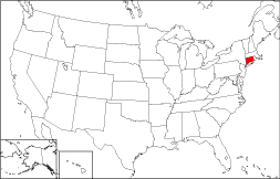
The State of Connecticut — whose location is highlighted in red on the adjacent map — is bounded by Massachusetts on the north, by Long Island Sound on the south, by Rhode Island on the east, and by New York on the west.
Connecticut Maps
Connecticut is the 48th largest state in the United States, covering a land area of 4,845 square miles (12,549 square kilometers). Only eight counties comprise this small state. This Connecticut map site features road maps, topographical maps, and relief maps of Connecticut. The detailed, scrollable road map displays Connecticut counties, cities, and towns as well as Interstate, U.S., and Connecticut state highways. The pannable, scalable Connecticut street map can be zoomed in to show local streets and detailed imagery.
Connecticut Highway Map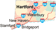 Click on the highway map thumbnail
to view a scalable Connecticut road map. |
CT Topo Map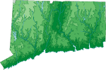 Click map to enlarge.
|
CT Relief Map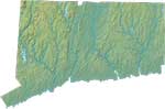 Click map to enlarge.
|
The detailed Connecticut map and the regional Connecticut map display cities, roads, rivers, and lakes as well as terrain features. The detailed map shows only the State of Connecticut, while the regional map shows Connecticut and the surrounding region.
Connecticut Infrastructure > Connecticut Airports
In 2005, the population of Connecticut was estimated at 3,500,701, which is about 724.5 people per square mile. In 2010, Connecticut's population rose to 3,574,097 people. More recently, in the 2020 census, the Connecticut population was 3,605,944. Connecticut is one of the most suburbanized states in the USA. The state's Interstate Highways include I-84, I-91, and I-95, and I-395.
Connecticut Topography and Attractions
The name Connecticut is derived from the Mohegan word Quinnehtukqut, which means "long river place" or "beside the long tidal river". The Connecticut River, New England's longest waterway, separates the eastern and western highlands. Mystic Seaport, the state's most noted tourist attraction, was an important shipyard during its 18th and 19th century heyday. Each year, thousands of visitors tour its restored buildings and ships. For more Connecticut travel and tourism information, visit the official Connecticut tourism site and Connecticut Atlas.
Other Connecticut Maps
This online Connecticut reference map shows major cities, roads, railroads, and physical features in Connecticut.Several map publishing companies offer printed maps of Connecticut. For example, Omni Resources offers several maps of Connecticut that feature points of interest, airports, and parks, as well as selected local attractions and insets of major Connecticut cities.
All rights reserved.
Certain maps hereon are © Map Resources or Digital Wisdom.
To facilitate browsing, certain external links will open in new windows.
Connecticut-Map.org Editor, State Maps, PO Box 828, Barnegat, NJ 08005.